ストーリー
Ⅰ. Volcanoes of Kyushu
by: Vicki L. Beyer
About volcanoes generally
The Japanese archipelago measures 378,000 square kilometers (146,000 square miles), making it the 63rd-largest country in the world by land mass. Yet Japan has the fifth-highest number of volcanoes, accounting for 10 percent of the world’s active volcanoes. Kyushu, in particular, is a land that was formed, and continues to be shaped, by volcanoes. To fully appreciate the energy of Kyushu, it is important to understand volcanoes.
The Japanese archipelago sits at the intersection of the Pacific, North American, Philippine, and Eurasian tectonic plates. All four are in constant motion due to the slow release of heat from the earth’s interior. As the plates move, often at an imperceptible speed, they collide and scrape against each other causing various kinds of seismic action.
Most volcanoes occur where tectonic plates are either pulling apart (so-called “rift zones”) or pushing under each other (so-called “subduction zones”). Volcanoes are said to be one of the most powerful forces of nature and subduction zone volcanoes are the most violent and destructive.
Kyushu sits on the Eurasian plate, near where it collided with the Philippine plate to its east. The Philippine plate sits under the ocean with the weight of the ocean’s water pushing it below the Eurasian plate, creating a subduction zone. The friction of the subductive action, added to the heat from the earth’s core, causes water and gases to bubble out of the rock of the plates, eventually melting the rock.
The melted rock mixes with water, gases and sediments to form magma, which is often trapped in magma chambers between one and 10 kilometers beneath the earth’s surface. However, due to the gases, which can include hydrogen dioxide, carbon dioxide, sulfur dioxide, hydrogen chloride and hydrogen flouride, magma is lighter than the solid rock surrounding it. So it begins to rise and push through weak spots in the solid rock. As it does so, the gases further expand and form bubbles. This rising, expanding magma places pressure on the earth’s crust, eventually breaking through at the weakest spots known as vents, forming volcanic eruptions.
The island of Kyushu was largely formed by these volcanic eruptions, predominately along a northeast to southwest line known as the Kyushu-Ryukyu Arc, a result of the subduction of the Philippine plate under the Eurasian plate. Effectively, the subducted Philippine plate melted and was expelled through volcanic action to accumulate on top of the Eurasian Plate to form new land.
Vulcanologists generally divide volcanic eruptions into two basic types:
● Effusive eruptions, when magma flows out of the volcano as a viscous liquid called lava; and
● Explosive eruptions, when magma is torn apart as it rises from the magma chamber so that it reaches the surface in pieces known as pyroclasts (from the Greek words pyro, meaning “fire,” and clastos, meaning “broken in pieces”).
Whether a volcanic eruption is explosive or effusive depends on the gases in the magma. When a lot of gases are present when the magma begins to rise, and the magma rises slowly so that more bubbles form, the bubbles cause the magma to break up and become chunky rather than viscous. In such cases, the magma often blows out of the vent explosively as rock fragments and as tephra (Greek for “ash”) particles. Conversely, if the gas bubbles don't begin to form until the magma has nearly reached the surface, the magma tends to remain liquid, so that it flows rather than blows out of the vent.
The material ejected from the volcano's “throat," which is the uppermost part of a vent, during an explosive eruption is a combination of hot gases and tephra known as pyroclastic flow or pyroclastic cloud. Because of the explosive nature of the eruption, pyroclastic flows move at very high speed, on average about 100 kilometers (62 miles) per hour, but sometimes as fast as 700 kilometers (435 miles) per hour. Pyroclastic flows often move away from the volcanic vent in two layers, with the heavier lava and tephra underneath—rolling down the mountain—and a cloud of ash and gases above. The flow can completely transform a landscape in a very short time.
Larger pieces of tephra (anything larger than a baseball) are known as bombs. Although some tephra bombs can literally weigh tons, the force of the explosive eruption enables them to travel great distances before coming to rest. Smaller bombs have been known to travel as far as 80 kilometers (50 miles); a 30-ton bomb was once found a kilometer (0.62 miles) from its source.
The smallest particles of tephra are volcanic ash. As ash is forcefully expelled from a volcano it often generates substantial static electricity, which in turn causes lightning within the cloud of ash. The minerals in the ash cause such lightning to take on different colors from those seen in the lightning formed during a thunderstorm, including reds and blues.
Ash clouds can rise several kilometers above the source volcano and then drift on prevailing winds, often remaining in the earth's atmosphere for two or three years after an eruption. Excessive amounts of ash in the atmosphere after major eruptions have been known to alter world weather. During volcanic eruptions, airplanes usually have to take care to avoid ash clouds, which can damage their engines and even bring them down.
Whatever the condition of the magma when it leaves the vent, as it cools and accumulates on the surface it may pile on top of itself to create a volcanic crater around the vent or even form new mountains (or raise the height of an existing volcanic peak). Alternatively, magma or tephra may flow or blow some distance from the volcano to create new land. Ninety percent of the earth's continents are produced by volcanic action, most of which are quite ancient. Yet this earth-building action continues today.
Sometimes magma cools and hardens before it leaves the vent, effectively plugging the volcano's throat and trapping the magma inside the earth. This can cause the earth to bulge as the magma pushes upward against the earth's surface until, eventually, the magma finds a new weak spot to break through, or enough pressure builds against the plug of cooled magma to push the volcano's throat open again in an explosive eruption.
Volcanic eruptions can be more powerful than the most powerful nuclear explosions, making them incredibly dangerous and unpredictable. And yet, humans continue to live and work near volcanoes.
One reason for this is the fact that lava and tephra often carry minerals and other nutrients from the earth's core that contribute to soil fertility. While molten lava is often extremely hard when it cools, it is broken down over time into highly fertile soil, thanks to the forces of nature such as plants that first take root in rock fissures. Meanwhile, volcanic ash becomes useful more quickly because it mixes readily with soil and contains the same minerals as lava.
Some pyroclastic flows, or even low-viscosity lava flows, spread out from volcanic vents to form broad, relatively level plateaus. Over time, forces of nature, including wind, rain and plant life, proceed to sculpt the landscape. Water drains downward, pooling to form lakes or flowing toward the sea in rivers that carry loose material such as rocks, soil and ash away from wherever the volcano originally dropped them, simultaneously shaping and carving the land as they flow. At the same time, plants taking root in rock crevices help break up the rock, while soil carried away by wind often catches in plant roots to accumulate and cover stone surfaces. Geologic time is measured in tens of thousands of years, but the work of natural forces to create landscapes from the moonscape of volcanic eruption is readily visible.
Kyushu was created and shaped by undersea volcanic eruptions that began millions of years ago. Even today, there are nine active volcano systems in Kyushu, two of which are regarded as among the most active in the world. Many people in Kyushu build their homes within sight of these active volcanoes, living and working alongside them. Kyushu people have great respect for the power of volcanoes and recognize their potential danger. At the same time, they are grateful for the abundance the volcanoes provide: fertile soil, plentiful water, even weather patterns that enable them to produce good-quality fruits, vegetables and livestock, and otherwise enjoy a wholesome and delightful natural world.
Mt. Aso/Aso Geopark
Mt. Aso sits roughly in the center of Kyushu at the junction of the Kyushu-Ryukyu Arc and an east-west line of volcanoes, comprising Unzen in the west and the Kuju-Renzan massif and Mt. Yufu to the east. This makes Aso particularly active and gives the volcanic system a number of distinctive features, including highly complex lithology (rock composition). Accordingly, the area was declared a national park in 1934 (the year Japan began its national park system). Now known as the Aso-Kuju National Park, it was officially designated a UNESCO Global Geopark in 2015.
UNESCO defines a geopark as “a unified area with a geological heritage of international significance.” Basically, the aim is to encourage close management to help educate the public about the geology of such an area while promoting sustainability. Public outreach efforts include fostering informed, non-destructive tourism. They also involve raising disaster awareness because many geoparks like Aso are geologically active, and are therefore potentially hazardous. At the same time, most geoparks contain substantial natural resources such as minerals that are useful to humans, and sustainable management ensures that any mining or other exploitation is done with integrity.
Japan has nine UNESCO Global Geoparks and 35 National Geoparks. Two global geoparks and six national geoparks are located in Kyushu.
Aso is well known for its expansive caldera. A caldera is a very large indentation or depression formed during a particularly violent volcanic eruption. During such an eruption, so much magma is expelled from beneath the earth so quickly that the magma chamber is emptied and the volcanic peak sitting above it simply collapses into it, leaving a rim around the collapsed area.
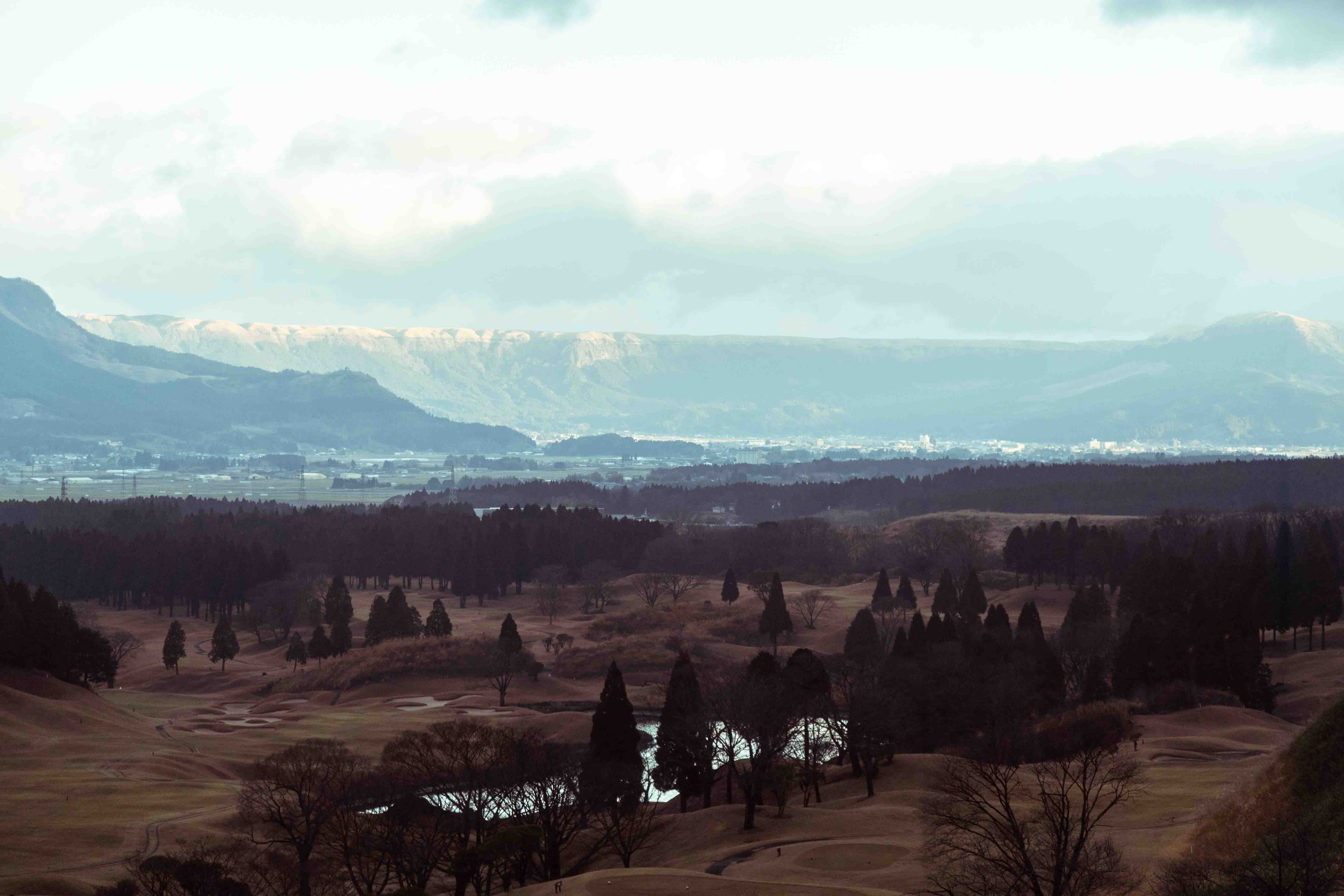
The Aso caldera measures 25 kilometers (15.5 miles) north to south and 18 kilometers (11.2 miles) east to west—a total of 350 square kilometers (135 square miles)—making it one of the largest calderas in the world. It was formed during four explosive eruptions with major pyroclastic flows, occurring between 90,000 and 270,000 years ago. The last of these is believed to have spewed at least 200 cubic kilometers (48 cubic miles) of magma/tephra. No wonder the mountain collapsed! Material from that eruption has been found across Japan.
The size and scope of the caldera is particularly obvious from the Daikanbo Observation Platform on the northern rim of the caldera. This northern rim has particularly steep sides, creating a very dramatic landscape. In summer, the lushness of the vegetation growing in cracks and crevices conceal the cliff-face to some degree. In winter, when many leaves are gone and grasses have turned a golden brown, the dark stone is more strikingly obvious.
Looking from Daikanbo into the caldera, the relatively flat floor forms a patchwork quilt of fields and paddies, criss-crossed by roads and settlements.
Many calderas become crater lakes, filling with water because of the rim left behind when the volcano collapses in on itself. Geologists believe that the Aso caldera has been a massive crater lake at least four times in its past. Looking at the steep rim of the caldera and the massive expanse inside, it is mind-boggling to imagine the size of past lakes that filled the caldera from time to time. Equally mind-boggling is the archeological evidence of human habitation around the rim of the caldera during periods when it was the shore of a giant crater lake. Even remnants of wooden boats have been unearthed.
Between 6,000 and 10,000 years ago, the southwest rim of the caldera broke and the most recent lake was drained. This break is now known as Tateno Gorge(Unfortunately, the gorge is currently inaccessible due to damage incurred during the 2016 Kumamoto earthquake.
). The stone in this area was created by basaltic lava flows, which often break into formations known as columnar joints when the lava cools rapidly. Rain and other water seep into the crevices in the rock between the columns and can weaken it to the point that the rock eventually gives way.
While that is most likely what happened, the local legend is that Takeiwatatsu-no-mikoto, one of the creation gods, purposefully kicked down the rim of the caldera to drain the lake so that he could bring rice farming to the area. Indeed, it appears that as soon as the lake had drained, humans moved to the caldera floor and began farming, finding the soil rich from both volcanic minerals and lake sediments.
Although the appellation Mt. Aso is commonly used when referring to the area, there is no mountain bearing this name. Since the formation of the caldera, the original vent at its center has continued to be active, with five separate peaks having formed over it, roughly in an east-west line. These are now collectively referred to as Mt. Aso, although each, of course, bears its own name.
Due to the varied heights and overall shape, the entire collection of peaks has been said to look like a giant statue of a reclining Buddha when viewed from Daikanbo. Nekodake is the easternmost mountain and is said to be the oldest of the five. Its crest is curiously jagged in shape, rather than rising to a single peak. There are a number of legends surrounding this odd yet peculiarly endearing shape. Surely, it is the unusual shape that leads many people to identify Nekodake as their favorite of the Aso peaks.
A local artist, Ms. Akemi Takatsu, often takes Mt. Aso, and most particularly, Nekodake as her subject. Born in Kumamoto in 1947, Ms. Takatsu studied dyeing techniques while at design school before launching her career as an artisan dyer. Her specialty is batik-style dyeing, painting an image on cloth with wax before applying dyes. She says she’s been fascinated with Nekodake most of her life and even climbed it in her youth. In a career spanning five decades, she has won a number of awards for her work, which includes not only designs on kimono and obi, but also hang-able art and everyday items like Western-style clothing and furoshiki. She has also produced drawings that have been converted to ceramic tiles, including a major ceramic relief that was installed at the Kumamoto airport in 2012. The mural is entitled “Mountain God on Clouds” and depicts a number of the Aso peaks, an appropriate symbol of Kumamoto to reside in the airport.
Of the five peaks, only Nakadake (1,506 meters/4,941 feet) is still active. It had several small eruptions in 2019. Aso is, in fact, Japan's most active volcano system. Prehistoric eruptions aside, the first of its recorded eruptions occurred in 553 AD. Since then, more than 165 eruptions have been recorded.
The area around Nakadake is a barren moonscape with smoke, steam and other gases, and even ash often rising from the crater. When Nakadake is relatively quiet, the Asosan Ropeway whisks visitors to its southern rim to look down into its crater, while the Suisenkyo Ropeway to the north terminates about 650 meters (2,132.5 feet) from the crater. However, following the recent eruptions, the Japan Meteorological Agency raised the eruption alert level for Nakadake in April 2019, so that currently no one is permitted within one kilometer of the crater.
To help visitors better understand the geological forces at work in the Aso area, 33 distinct “geosites” have been designated within the Aso Geopark. Geosites are locations within the geopark that are of particular importance. There is usually detailed information available at these sites to help visitors learn more about the geological forces at work. The abovementioned Daikanbo northern rim of the caldera and Nakadake itself are two such geosites. Another is at Kusasenri, where the Visitor Center/Aso Volcano Museum and the Kusasenri-ga-hama Observation Station are located. Kusasenri-ga-hama is a grassland area inside a one-kilometer-wide crater formed about 30,000 years ago. There is actually a smaller crater inside the large crater and each crater has a small pond on its floor. From Kusasenri, visitors can usually have excellent views of Nakadake, about three kilometers (1.86 miles) away, as well as the other Aso peaks.
The Aso Volcano Museum contains exhibits on volcanoes and the geology of the Aso area, as well as information on the resultant topography and its impact on the plants, animals and people of the area. It provides audio guides in four languages, including English. There is a particularly interesting mechanized exhibit on how the volcanoes grew and shaped the land over millennia. Don’t miss the very informative short movie about the volcano that plays on a loop in a small theater on the top floor. There is also closed circuit TV enabling visitors to peer into the Nakadake crater, which is especially valuable during times when it is off-limits to visitors.
There is a well-established trail from the Visitor Center across Kusasenri-ga-hama toward Nakadake (at least as far as visitors are currently permitted to approach). Observation decks above the Visitor Center also provide a different view of the Aso peaks, Kusasenri-ga-hama and the surrounding area.
The Visitor Center in the museum contains displays on the park’s different geosites, and provides visitors with information to facilitate their visits to the area. Brochures available at the Visitor Center enable tourists to undertake self-guided tours of the various geosites, using private cars or the Aso Geopark Bus, a shuttle bus that ferries visitors around the geopark from the Aso train station.
One feature that can’t be missed by visitors traveling to the Visitor Center from the caldera floor is a lone cinder cone, standing about 50 meters high. It looks a bit like an upended Japanese rice bowl, which perhaps explains its name: Komezuka (rice mound).
For tourists visiting the area, outdoor activities abound. Hiking, mountain biking and even horseback riding are all popular activities in this area. Guided nature walks and multi-day treks are also available.
Farming is a popular occupation inside the Aso caldera; fields and greenhouses can be seen across the caldera floor. The breadth of the caldera, its relatively level floor, and the fertile soil produced by the eruptions and the lakes have lured humans to live inside and around the caldera for millennia, in spite of the high level of volcanic and other geological activity in this area. All manner of fruits and vegetables are grown on farms inside the caldera (see “Cuisine”). Hajime Nonaka, a Fukuoka native who moved to Minami Aso 25 years ago to start an organic farm loves the pace of his life inside the caldera. He and his wife have raised two children while living in a 70-year-old farmhouse. He loves the fresh air, good soil and clear water that all help his crops to grow. His wife, Keiko, gives cooking lessons to both locals and tourists. She has also compiled a cookbook of recipes she has developed using local produce.
The Aso area is also well known for raising beef cattle. It is said that locals know an eruption is imminent when the cattle refuse to graze on the flanks of the peaks.
Even outside the Aso caldera, the landscape has been shaped by Mt. Aso’s eruptions, including the mountains stretching east and south from the caldera.
At Takachiho in the mountains of northern Miyazaki, some 35 kilometers (22 miles) southeast of Nakadake, the Gokase River has carved a 20-meter (65 feet) deep gorge through layers of volcanic lava flow. The narrow chasm has nearly sheer sides but the way in which the shape of the basalt changes partway down reveals two separate lava flows. The upper layer is attributed to the massive eruption 90,000 years ago that created the Aso caldera, while the lower layer is said to be from an eruption 120,000 years ago. Out of sight, below the waters are lava layers formed 140,000-270,00 years ago. Manai Falls is a fascinating ribbon of water plunging 17 meters (56 feet) into the narrowest part of the gorge. The best views are to be had by renting a row boat to enter the gorge, but viewing platforms above and at the top end where the river enters the gorge also provide an excellent perspective. There is also a trail farther upriver to explore parts of the gorge, where its walls are less dramatic but the power of the water is more obvious.
An even more spectacular waterfall created by an Aso eruption is Harajiri Falls on the Ogata River in Oita Prefecture, about 30 kilometers (18.5 miles) west of Mt. Aso. Falling 20 meters (65 feet) over a horseshoe-shaped span of 120 meters (394 feet), located in the middle of an otherwise broad valley, Harajiri Falls has been called the Niagara Falls of Japan. It is also believed to have been created by pyroclastic flow from Aso’s eruption 90,000 years ago. The falls are popular with tourists and there is even a suspension footbridge across the river below the falls to allow better viewing.
Kuju Renzan
Just east of Mt. Aso lies the Kuju Renzan, a 13-kilometer (8 mile) long cluster (known in geology as a massif) of 10 volcanic peaks. Known as the “roof of Kyushu,” this volcano system is credited with the volcanic flow that created the landscape of Oita Prefecture, including its many well-known and popular onsens (hot springs).
The tallest of Kuju Renzan’s peaks is also known as Mt. Nakadake. At 1,791 meters (5,876 feet), it is the highest peak in Kyushu, although the views from nearby Mt. Kuju (1,787 meters/5,863 feet)) are said to be better.
Nine of Kuju Renzan’s 10 peaks are dormant; only one, Mount Hossho (1,762 meters/5,781 feet), has erupted recently. It erupted without warning in 1995 and has remained active ever since, with steam regularly billowing from several vents on its slopes.
In spite of this, Kuju Renzan is a particularly popular hiking area, with a network of well-maintained trails that are both fun and scenic. Although the peaks are usually snow-covered from December to March, properly equipped hikers take on the trails year-round. These are serious peaks and appropriate gear is essential, as is submitting a mountain climbing registration form, in case of emergency.
The four distinct seasons enjoyed in this area provide visitors, especially hikers, with various delights ranging from the mountain azaleas of early summer to the vibrant colors of the autumn leaves. It seems any season without snow will offer wildflowers of some variety.
A great place to start any visit to the area is the Chojabaru Visitor Center, just off the Yamanami Highway, which is part of the popular Trans Kyushu Route. The center has helpful staff and informative displays in Japanese, English and Chinese to help visitors learn more about the area and how they can enjoy it without damaging its natural splendor.
In the valley below the peaks, there are two distinctive wetland areas: Tadewara and Bogatsuru. The Chojabaru Visitor Center is just next to the Tadewara wetland, where boardwalks allow even casual visitors to spend 20 minutes to an hour exploring and learning about the importance of wetlands, within view of the Kuju peaks, without interfering with the potentially fragile ecosystem. Here too, different plants bloom in different seasons. Even birds, bees and butterflies have their seasons when they are present. One particularly fun winter activity is looking out for animal tracks. Various small mammals also inhabit the area.
Unzen Volcanic Area Global Geopark
Kyushu’s other UNESCO Global Geopark also centers on a volcano: Mt. Unzen.
Similar to Kuju Renzan, Unzen is a collection of volcanic peaks, forming the Shimabara Peninsula. During Unzen's eruptions between 1991 and 1995, a new lava dome formed to become the highest peak in the massif. Dubbed Heisei Shinzan (the new mountain of Heisei), the 1,483-meter (4,866 feet) peak is half a kilometer east of Fugen-dake (1,359 meters/4,459 feet), formerly the highest in the cluster. Several of the eruptions produced lahars, pyroclastic flows that contain a substantial amount of mud formed by wet conditions, including the flows moving down a river course. These were simultaneously destructive and constructive, reshaping the landscape and the coastline.
Video and other scientific data from Unzen's most recent eruptions have contributed substantially to the scientific world's understanding of volcanoes. Dramatic video shot by a television cameraman on June 3, 1991 can be viewed at the Mount Unzen Disaster Memorial Hall in the city of Shimabara, a museum with interactive exhibits that help visitors understand the violence of volcanic eruptions. One exhibit uses red lights in the floor to demonstrate the speed and destruction of pyroclastic flow.
The eruption of the 1990s was similar to an eruption in early 1792 that emitted lava and pyroclastic flows that ultimately caused the east flank of Mayuyama, another peak in the Unzen massif, to collapse on May 21, 1792. This resulted in landslides eastward into the Ariake Sea. A legacy of these landslides is visible today—hummocky hills between the mountain and the shore, as well as small islets just offshore formed by large boulders and similar detritus. Even after more than two centuries, the sea floor is similarly littered with such debris.
A ferry port linking the peninsula with Kumamoto Prefecture on the other side of the Ariake Sea, the city of Shimabara is a kind of gateway into the geopark. While the geopark does not have an official visitor center, Mount Unzen Disaster Memorial Hall is a good place to begin a visit. Visitors can learn about the peninsula's volcanic past and pick up tips on how to explore that history.
The Heisei Shinzan Nature Center, situated about halfway between Shimabara City and Unzen's volcanic peaks, is another great place to get information on the volcano and the recent eruption and its impact. Displays about the revival of plants are particularly worthwhile. Boardwalks and other paths in the area allow visitors to see how plants and animals have quickly returned after such a major eruption.
Scientists estimate that the Unzen volcanic system has been active for at least 4.3 million years, although it was undersea for much of that period. Black basalt rock on the Hayasaki Peninsula, a small protuberance at the very bottom of the Shimabara Peninsula is believed to be the oldest rock created by Unzen. A cliff at Tatsuishi Beach on the southeastern shore of the Shimabara Peninsula exposes layers of rock and soil of different colors deposited by volcanic eruptions over the past 500,000 years.
The Shimabara Peninsula is joined to the rest of Nagasaki by an isthmus that’s just six kilometers wide. The Chijiwa fault runs 14 kilometers (8.7 miles) east-west along the southern shore of the isthmus, seemingly trying to tear the peninsula away, albeit at the rate of just 1.5 millimeters per year--that's 1/24 of the speed at which human fingernails grow. Evidence of the fault is visible at the Chijiwa Observatory.
Farther down the peninsula's western shore is a small protuberance called the Kunisaki Peninsula, where there are still visible remnants of a viscous andesite lava flow from an eruption 1.5 million years ago. About five kilometers (3.1 miles) south of the Kunisaki Peninsula, a curious rock formation called Futagoiwa sits right on the rocky shore. The formation, also andesite, looks a bit like one of Easter Island’s iconic moai statues and is the product of wind and water erosion.
Generally, the western side of the Shimabara Peninsula seems less impacted by the Unzen volcano, except that local farmers regularly attribute their delicious vegetables to the fertile soil created by the volcano. Others who are lucky enough to enjoy a meal in this area will be quick to agree.
Kirishima
Straddling the boundary between the Kagoshima and Miyazaki prefectures in southern Kyushu sits Kirishima-Kinkowan National Park/Kirishima National Geopark. Kirishima literally means "fog island,” a name possibly derived from the prevalence of fog in this region, often making the volcanic peaks appear as an island in a sea of fog.
The Kirishima volcanic cluster comprises 18 volcanic peaks in a complex system that, from the air, appears to be pockmarked with circular craters, some long dormant and filled with water to form scenic crater lakes. Different peaks have erupted at different times over the past 300,000 years to create this distinctive landscape. The area occupies the southern rim of a much older caldera, but remains active, with the most recent eruption of Mt. Shinmoedake in June 2018. While the ongoing risk of further eruptions has led to restricted areas inside the geopark, avid hikers still find plenty to explore.
The volcanic peaks of Kirishima are a delight to vulcanologists, offering a cornucopia of different mountains, the result of various diverse types of eruptions and lava. Visitors can get details and information about all the peaks and other features of the area at the Ebino Eco-Museum Center, which is regarded as the principal visitor center for the geopark, or from local information centers in the several towns inside the geopark. There are also nature centers in the three cities of Kirishima, Miyakonojo and Kobayashi, all dedicated to educating visitors about the topography, flora and fauna of the area.
Some Kirishima craters have become crater lakes. From Ebino Eco-Museum Center, there is a relatively easy two-hour hiking course that covers three such lakes with a chance to roam through the grassland, woodland and shrubs that surround the lakes, while also offering views of Mt. Karakuni to the south. Deers are abundant in this area and are often seen grazing. Late in the day, lucky hikers may also catch sight of smaller mammals.
Besides the peaks and craters, there are gorges, rock formations and waterfalls formed by the forces of nature working on lava flows from eruptions over the millenia. A number of self-guided tour courses (some require a private car) have been developed for exploring these particular features of the geopark. Details are available from the various information centers. It is also possible to join guided hiking or trekking tours of the area. Horseback riding and bicycling are also popular here.
There are a number of beautiful waterfalls in the area, including some rather unusual ones. Maruo Falls, not far from the Kirishima Hot Spring area, has blue-white water that smells of sulfur. As one might expect, its waters come from a spring. The 23-meter falls is illuminated at night during certain seasons, providing a completely different feel. On the other hand, Kirihara Falls on the Mizonokuchi River is best viewed on a sunny day when the mists of this 15-meter-tall and 60-meter-wide falls create rainbows. Sentaki Falls comprises groundwater emerging partway down a cliff of volcanic rock that then tumbles into the Kirishima River.
One particularly popular waterfall is the 36-meter Inukai Falls. The sheer rock face and the erosion at the top of the falls make for a fascinating study of how volcanic eruptions impact a landscape. It's likely that the popularity of this waterfall has more to do with its association with a hero of the Meiji period, Sakamoto Ryoma (1836-1867), who is said to have visited here with his bride on their honeymoon in 1866.
Of the peaks in the Kirishima cluster, Takachiho-no-mine, in the southeastern part of the cluster, is closely associated with Japan's origin myths. It is the purported location of the descent from heaven of Ninigi-no-mikoto, the imperial ancestor said to have introduced rice cultivation to Japan. A replica ancient weapon is embedded in the mountain's summit to mark the spot of the descent (see “Spiritual Island”). It is about a three-hour round trip from the Takachihogawara Visitor Center to the spot where the weapon is embedded. The ascent is a serious climb that trekkers want to be sure to be properly equipped for. Although it is an ascent the priests of Kirishima Jingu make regularly for purposes of religious rituals, even they wear proper hiking boots with their priestly robes.
Volcanoes near Kagoshima City
Sakurajima is an active volcano that sits in Kagoshima Bay. It is the hot spot on the southern end of the Aira Caldera that resulted from a massive “blow out and cave in” volcanic eruption some 29,000 years ago. At that time, most of the caldera was inundated by the ocean's waters to form the top end of Kagoshima Bay. As often happens after a caldera forms, the volcanic hotspot continued to be active, eventually forming Sakurajima.
Sakurajima’s first recorded eruption was in 963, which is perhaps when the lava build-up of the volcano reached the surface of the bay to form an island. It remained an island until lava flow from a 1914 eruption connected Sakurajima to the eastern shore of Kagoshima Bay. Apparently, after that eruption, local fishermen said they should have realized an eruption was coming when their boats encountered a line of drowned rodents not far from the then-island. Animals seem to sense coming eruptions earlier than humans do, and the rodents were attempting to flee the perceived danger.
For a poignant reminder of the impact of lava and lahar, visit the Kurokami Buried Shrine Gate on the western side of the peninsula, a couple of kilometers above the new isthmus joining the volcano to the mainland. Three quarters of the concrete shrine gate was buried in the 1914 eruption, leaving only its beam peeking out.
Sakurajima’s volcano continues to be active, regularly belching smoke and ash onto the city of Kagoshima just eight kilometers (five miles) across the bay, as well as on the surrounding countryside. In spite of the high level of volcanic activity, many farmers still live and work on the flanks of the volcano, often working near concrete bunkers where they can quickly seek refuge if/when the mountain belches out tephra bombs. Visitors to Sakurajima are often intrigued to see little roofs over graves in local cemeteries, erected to keep ash off the graves.
Sakurajima is accessible from the west by private car, or by a 15-minute ferry ride across the bay. Visitors are recommended to begin their visit at the Sakurajima Visitor Center, just a few minutes’ walk from the ferry landing.
When there are heavy ash eruptions from Sakurajima and the wind is blowing from the east, the ash falls like snow on the city of Kagoshima. When this happens, footsteps are muffled exactly as if one was walking on newly fallen snow. The city also issues sandbags for locals to shovel ash into. City workers then collect the bags, exactly as they would collect garbage, and arrange for their disposal outside the city. The city also sponsors programs to recycle the ash for new uses.
Because of the shape of Sakurajima as a peninsula jutting into Kagoshima Bay, the northernmost part of the bay is home to some distinctive life forms, including playful dolphins and some 1,000 species of fish. There are also a number of minerals and rare metals on the bay floor, and even a vent spilling out heated water.
The Ibusuki Volcanic Field formed the land that is the western side of Kagoshima Bay. One of its most popular features is the pyramid-shaped Mt. Kaimon, sometimes called the Fuji of Kyushu. Although there have been no eruptions for more than 1,000 years, the area is renown for its geothermal activity. At Ibusuki Hot Springs on the southern tip of the peninsula, one popular activity is sand bathing. Bathers garbed in cotton yukata robes are buried in the naturally heated sand to soak up the therapeutic heat, often within earshot of waves breaking on a beach (see “Onsens”).
Volcanoes of coastal islands
Kyushu Island is surrounded by a number of small coastal islands, many of which are also the product of volcanic activity.
Beginning about 40 kilometers (25 miles) south of the mouth of Kagoshima Bay, extending toward Okinawa, is a cluster of nine islands known as the Osumi Islands. Lying on the Okinawa Arc, the islands are of volcanic origin. Iojima Island is host to an active volcano, Mt. Iodake, and sits on the western rim of the Kikai caldera, a mostly submerged structure created during a massive eruption about 6,500 years ago. When viewed from the approaching ferry, English-speaking tourists may find themselves humming the theme from "Gilligan's Island.”